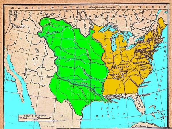
2. Map of Louisiana, 1800 to 1804, purchased from France for
$15,000,000.00
Map: Green is Louisiana. It is divided into two parts. The upper
part was Spanish Louisiana and it was composed of (1) the lands above
the Missouri River that were previously (before 1763) French Louisiana,
and (2) the lands below the Missouri River which were Spanish Louisiana
and contained 6 Bulls Indian Confederation which had been under
sovereign to Spain 1541 AD to 1800. The bottom green lands were part of
the Caddo Indian Confederation that were ceded to France in lieu of the
lands that Spain was unable to return as per the 1800 Treaty
FRANCE/SPAIN.
Explanations:
In 1800 Spain was
forced to return the remnants of Louisiana to France due to treaty
violations of the 1763 treaty of Paris and the amendments thereafter.
In 1762 three countries claimed the TRANS MISSISSIPPI RIVER BASIN
(middle North America): Spain, France and Britain.
Spain had claimed the same region since her papal
line, which extended back to the years of Columbuss
voyages. This was ignored by other countries who had been
fishing there in secret for 100s of years. So Spain again
claimed it, after it was discovered by her Cuban Govenor
that North America was a continent and not an Island.
Britain claimed it due to her Virginia settlement
Charter in 1607 and in her eagerness to populate the Basin
area (the lands that extended sea to sea), had imported
Scots-Irish in mass migrations since 1733. She had it
settled as her Augusta County of the dominion of Virginia.
France claimed it based on explorations extending
back to 1603 and her occupation of Quebec, then expansion
south into the basin.
Prior to 1762, the British Scots and Irish immigrants in the
TRANS MISSISSIPPI BASIN became numerous and organized to overthrow the
power of Britain, France and Spain. They wanted their independence and
to name the Trans Mississippi River Basin as the country of NEW
SCOTLAND. Fearing this, Spain and France met in secret, by 1762, in
Paris, France, to settle their dispute of claims and to try to contrive
a way to control the invasion of the Scots-Irish. They divided the
Basin between themselves thus..... Spain was to keep her Florida lands
east and west of the Mississippi River. (The lands to the west were the
6 Bulls Indian confederation and the lands to the east were Spanish
Florida providence) and France was to keep her lands above the Missouri
River west of the Mississippi River as well as the lands east of this
river to the Water shed of the Appalachian Mountain watershed. But the
deliberations continued. France was in a poor position to maintain her
North America provinces due to her wars. So again the two countries
arbitrated and this time they agreed on a on the same divisions, but
France was to cede to Spain her North American claims in return for
lands in Tripoli and commodities (ammunitions from the 6 Bulls Indian
confederation was one of many of the commodities agreed on). Spain
wanted the east of the Mississippi River lands to bargain with Britain
to control her rebellious Scots-Irish and force them to honor her
boundaries.
Britain was upset over being excluded in this manner that France
and Spain expected her to lap up the crumbs tossed to her by this
treaty. England knew if she did not act on the treaty proposal, then
the rebellious Scots-Irish would declare independence and she would
lose everything, just as Spain and France would. So Britain accepted,
but demanded more lands......among which were those north coastal
lands (the tip of present day Maine and Nova Scotia) claiming that she
would give amnesty to the leaders of the rebellion and give them their
own country, on the condition that they could not name it NEW SCOTLAND.
But they did the next best thing......they named it NOVA SCOTIA which
is Latin for NEW SCOTLAND.
1802/3 the USA purchased French LOUISIANA from France and it
retained the same dementions until 1804
Verifications:
Book: A History of Missouri by David Muzzy, published 1936.
Map rendered by Frances Deis Harris, elementary school level
teacher, used 1896 to 1938 to teach her students. Owned by her
granddaughter Jo Ann Louise Harris Hamilton Fischer.