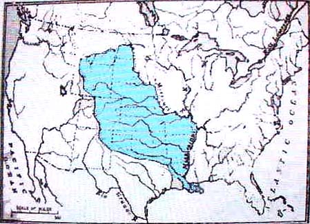
1. Map of 6 Bulls Indian Confederation 1541 to 1808 under sovereign
of Spain, France and USA.
Description: "6 Bulls Indian Confederation"
under the sovereign of Spain from 1541 to 1800,
then in 1800 to 1802-3 under the sovereign of France,
then in 1802-3 to 1808 under the sovereign of USA.
1808 Purchased by the USA.
1808 Treaty disputed in 1809. The dispute lasted until
1828 and treaty deemed valid. All this time, 6 Bulls was
protected by the grandfathered Treaty of 1541 which
protected 6 Bulls from non 6 Bulls Indian inhabitation but
allowed 6 Bulls to leases it or parts of it at will.
Verifications of the map:
Known Journals of De Soto, pub. 1993 in Spain and a
summary put on the internet with maps of DeSotos journeys
as verified by a team of scientists.
A History of Missouri, 1936 David Muzzy. which gives
a description of 6 Bulls.
Ownership of map. Jo Harris Fischer who copied the orginal
map rendered in 1853 by Joseph Malites Span, son of
Aaron Span and sent to his sister Elizabeth Span Miller to
teach her children about Missouri History. Joseph Span and his
wife according to the 1870 Jackson Co., MO, Federal Census did not
read and write so they had to hire someone to write his letters
and construct the map.